
By Siraj Asfahani | October 13, 2014
Over the years, the Lakota Group has had a fruitful working relationship with the communities that comprise the Quad Cities metropolitan region. In 1998, Lakota, in collaboration with 18 Quad City communities and various other local non-profit groups and agencies, created the Mississippi River Corridor Land Use Plan and Design Principles, a comprehensive planning document that addressed issues related to river access and open space, bike trail connections, wetland conservation, landscaping and sustainable design, and wayfinding and public art along a 26-mile stretch of the Mississippi River waterfront. For its compelling vision and creativity in addressing complex waterfront design and planning issues, the Plan and Design Principles received awards from both the Illinois Chapter of the American Society of Landscape Architects and The Waterfront Center in 1999. The Plan has been faithfully implemented over the years resulting in a network of amenities, trails and wayfinding systems that bind the Quad Cities together with the region’s most important natural resource – the mighty Mississippi.
Now, more than 16 years later, one of the Quad Cities – the City of Moline, along with Renew Moline, the City’s private-sector development partner, have both been honored with a Best Strategic Plan Award from the Illinois Chapter of the American Planning Association for the development and adoption of the Moline Centred – Riverfront Neighborhoods Comprehensive Plan Update. Lakota is very pleased to have served as the project’s lead planner. The City and Renew Moline received the award on October 2 at the Illinois Chapter’s annual conference in Evanston.
The Moline Centred project updates the City’s Comprehensive Plan for three sub areas: Moline Centre – the City’s downtown commercial district, and the Floreciente and Edgewater neighborhoods, two traditional neighborhood districts that flank Moline Centre on the west and east respectively. The Moline Centred – Riverfront Neighborhoods Comprehensive Plan Update, as the planning document is titled, was adopted by the Moline City Council this past April. Lakota was assisted by T.Y. Lin International of Chicago, the Community Land Use and Economics Group of Philadelphia and the Planning Guild of Pittsburgh.
The Moline Centred Plan addresses a number of issues related to land use; the revitalization of Moline Centre’s historic core; conservation of neighborhood housing; urban design and streetscape improvements; small business development initiatives; the transportation and roadway network through Floreciente, Moline Centre and Edgewater; organization capacity-building; historic preservation; sustainable design and flood mitigation; and design and landscape enhancements along the Mississippi River waterfront. The Plan also focuses on land development scenarios for the Interstate 74 Realignment Zone, where the construction of a new Interstate 74 Bridge is slated to begin in the next few years, and the Quad Cities campus of Western Illinois University, which is already expanding along Moline Centre’s eastern edge.
Working with the City, Renew Moline and a 14-member Project Steering Committee, Lakota and its team partners pursued a planning approach that created 21 strategic planning actions and comprising a combination of “big-picture” and “small-scaled, grass roots-oriented” planning and revitalization strategies for Moline Centre and the two neighborhoods. The planning process also incorporated a multi-faceted approach to community engagement, including open houses, neighborhood tours, online surveys and electronic outreach, stakeholder interviews and newspaper editorials.
As with the Mississippi River Corridor Land Use Plan and Design Principles, we hope the Moline Centred Plan provides the vision and strategic direction for continued reinvestment and revitalization in Moline’s downtown and waterfront neighborhoods.
For more information and to view a copy of the Moline Centred: Riverfront Neighborhoods Comprehensive Plan Updates, please view the Moline Centred website at www.molinecentred.com.
Images from the Moline Centred Plan:
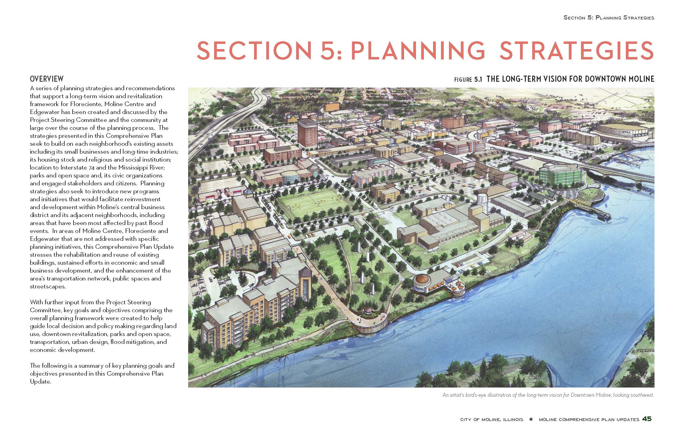
Overall land development scheme for the eastern edge of the Interstate 74 Realignment Zone.
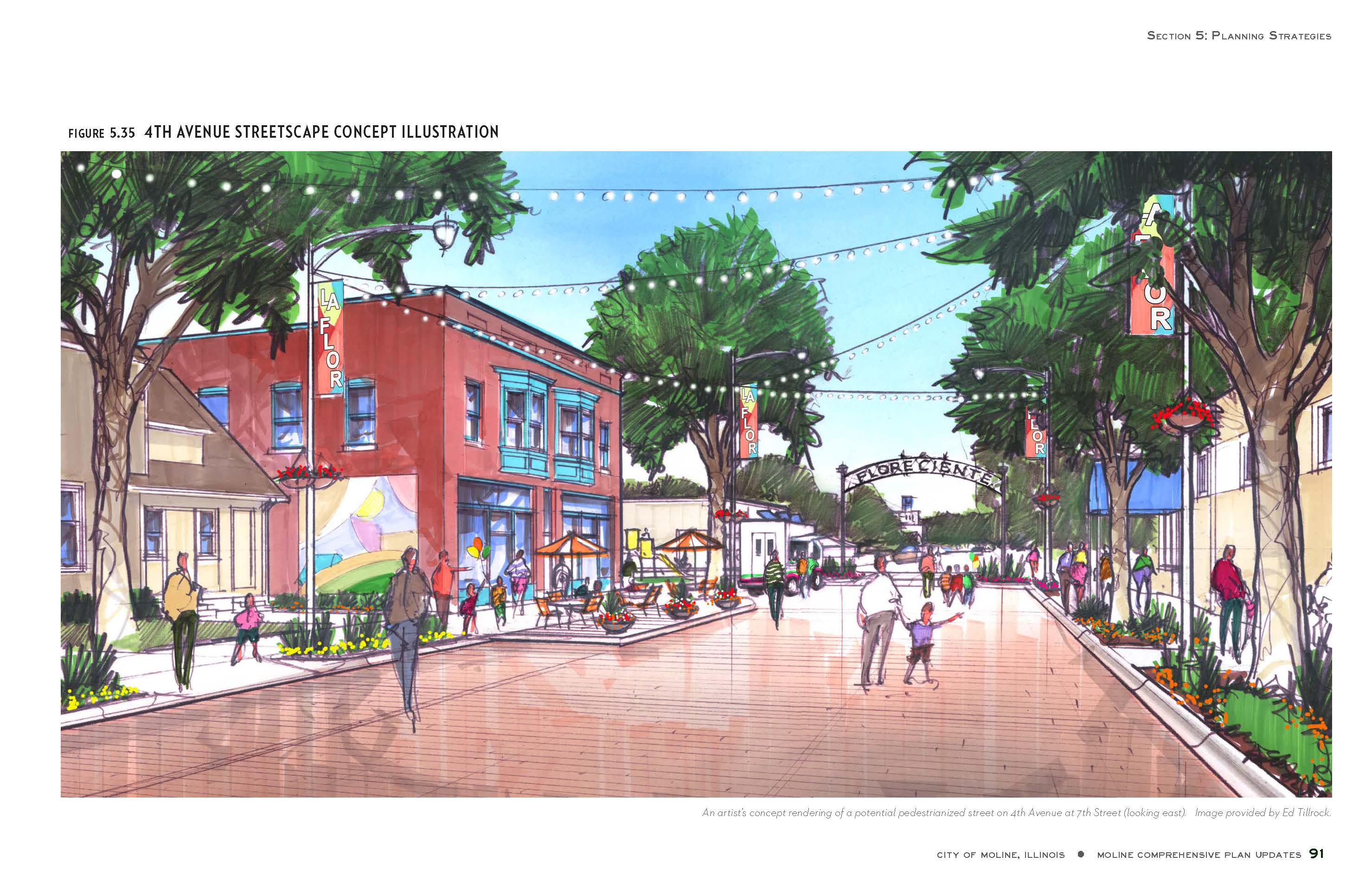
Neighborhood node streetscape enhancement scheme for Floreciente
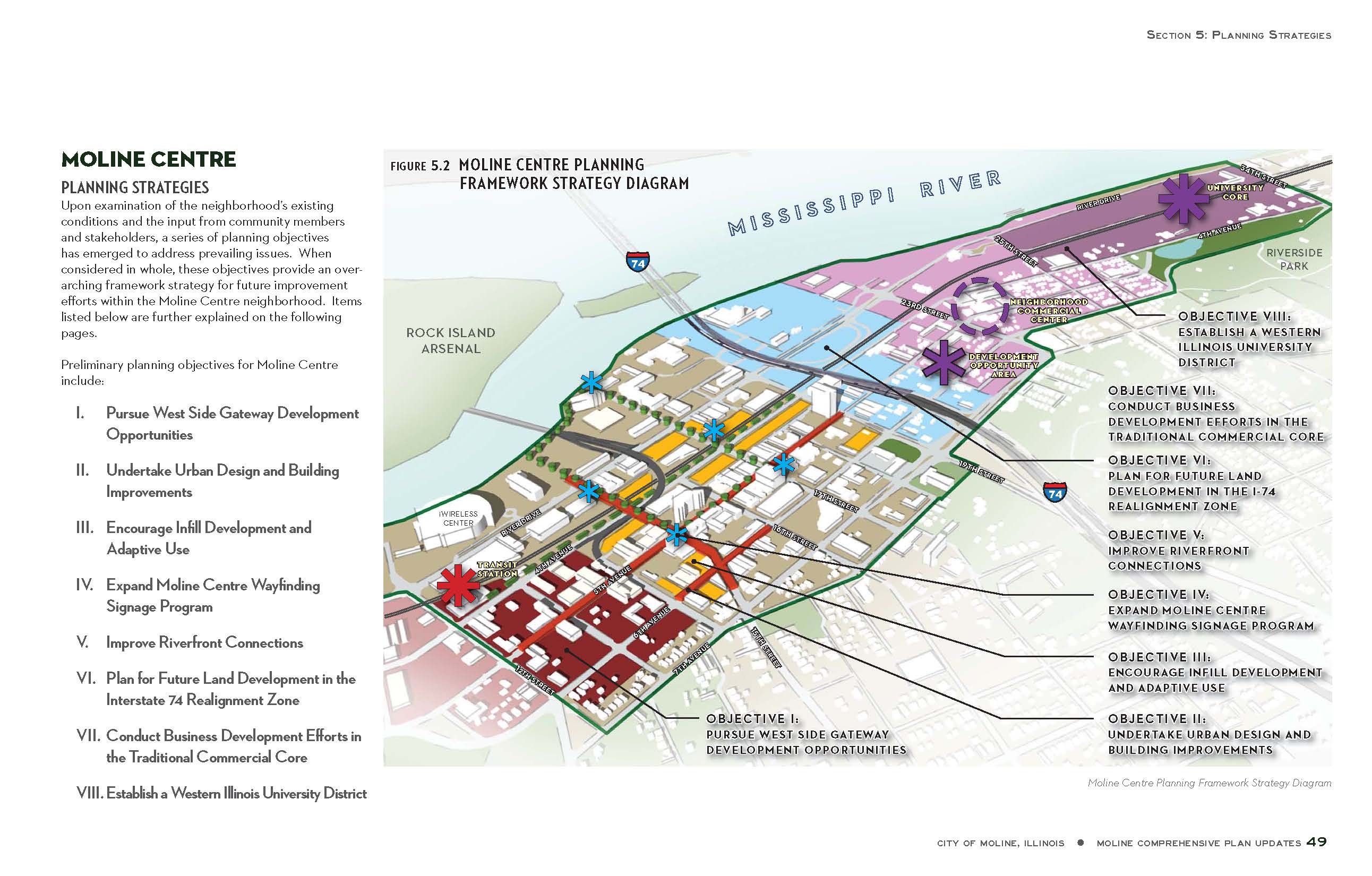
Moline Centre planning framework map.