
By The Lakota Group | May 29, 2018
Since 1993, comprehensive and regional planning has evolved from land use “bubble maps” to strategic thinking on community resiliency, placemaking, and quality of life. Comprehensive plans must also inspire communities to be stewards of their own future and active participants in implementation. Lakota has completed numerous comprehensive plan assignments over the years in large cities, small towns, and suburban communities. Here’s a list of a few of the comprehensive and regional plans we have done over the past 25 years. Check out our project page to learn more!
Crown Point Comprehensive Plan, 2005
Lakota prepared a Comprehensive Plan and Development Guidelines for this Northwest Indiana community to guide the city in future land-use decisions and to maximize its potential annexation areas — a total of 25,000 acres. The Plan included a greenbelt/growth boundary to encourage efficient use and development of municipal services, and accommodated a population of 58,000, nearly triple the previous population of 20,000.
West Dundee Comprehensive Plan, 2005
Lakota prepared a Comprehensive Plan that integrated the community’s land-use, economic development, and transportation components. The Plan set a feasible development framework for the Village while concentrating on strategies for maintaining and developing four key sub-areas: Spring Hill Regional Mall, Route 31 Corridor, Randall Road Corridor, and Historic Downtown. S.B. Friedman & Company conducted a market study for several land uses and identified gaps in the market. Lakota and Friedman then crafted development strategies based on the Village’s market position and physical setting.
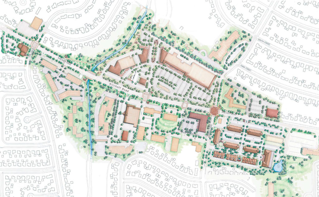
Downtown Development Concept for Rolling Meadows
Rolling Meadows Comprehensive Plan, 2006
In 2005, the City of Rolling Meadows initiated a planning process to update its 1993 Comprehensive Plan and address City-wide improvement and development. The process was an important opportunity for the City to build upon recent planning studies for the City’s key development sub-areas, including Downtown Kirchoff Road, Corporate Park North, Corporate Park South, and TOD District West. Land use, physical conditions, and quality of life elements were reviewed and improved through plan recommendations.
East Chicago Comprehensive Plan, 2008
Lakota worked with the City of East Chicago in crafting a Comprehensive Plan that includes land use strategies which emphasize neighborhood revitalization, consolidation of commercial districts/corridors, increased open space, and economic development of the city’s underutilized land. Development concepts included two large business parks and a “supplier” village that would serve the Gary Chicago Airport. Land use transitions and buffers, along with physical improvements were introduced throughout the city. Strategies included preservation of several historic properties in addition to the Marktown neighborhood.
Gary Comprehensive Plan, 2009
Lakota led a team that prepared a comprehensive plan for the City of Gary, Indiana. The plan included land-use strategies for this 50-square mile community, incorporating focused design efforts on the city’s lakefront, industrial districts, historic downtown, commercial areas, neighborhoods, open spaces, and greenways. The strategies and urban design concepts addressed deteriorating physical conditions, job losses, land use conflicts, and neighborhood consolidation.
LaSalle Comprehensive Plan, 2014
In February 2014, The Lakota Group, along with T.Y. Lin International and the Community Land Use and Economics Group Group—completed a comprehensive plan for the City of LaSalle, Illinois. The plan, funded by the Illinois Department of Commerce and Economic Opportunity Hurricane Ike Recovery Program, involved creating and prioritizing planning and implementation strategies for LaSalle’s long-term flood prevention efforts and community and economic development. Implementation strategies addressed critical issues related to adequate infrastructure, enhanced aesthetics, downtown business development, housing, parks, open spaces, transportation options, historic resources, and achieving a more diverse and sustainable economy.
Springfield-Sangamon Regional County Master Plan, 2014
The Lakota Group was engaged by the Springfield-Sangamon County Regional Planning Commission to prepare a Regional Plan for Sangamon County, which includes the City of Springfield and 26 other townships, municipalities and unincorporated communities. The Plan was part of a multi-year stakeholder engagement process undertaken by the Springfield-Sangamon County Regional Planning Commission to determine critical regional planning issues related to land use, economic development, agriculture, open space and recreation, historic preservation and tourism, sustainability and quality of life, and intergovernmental cooperation and efficiency.
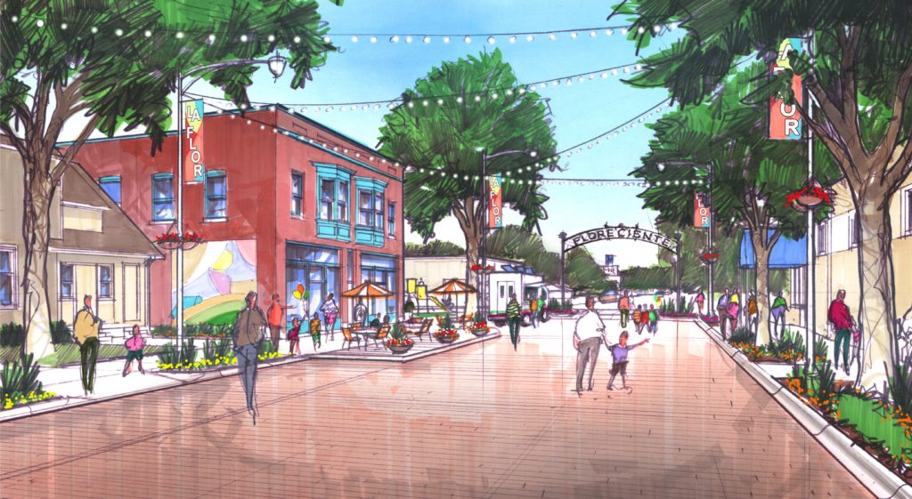
Rendering of Floreciente Neighborhood in Moline
Moline Riverfront Neighborhoods Comprehensive Plan Update, 2014
The Lakota Group, along with T.Y. Lin International, the Community Land Use and Economics Group, and the Planning Guild, were engaged by the City of Moline and Renew Moline, a private-sector development group, to undertake a collaborative process for updating the Moline Centre, Floreciente, and Edgewater Neighborhood Master Plans. The updates addressed the City of Moline’s issues related to downtown revitalization, land use, neighborhood housing, urban design and streetscape improvement, small business development initiatives, transportation and roadway networks, and enhancements to the Mississippi River waterfront.
Chadron Comprehensive Plan Update, 2015
The Lakota Group, along with Baker Engineering and Urban Development Services, completed a new Comprehensive Plan for the City of Chadron, Nebraska in January 2015. The Plan updated an earlier comprehensive plan from 1997 and addressed issues related to neighborhoods and housing, growth management and city infrastructure, parks and open space, urban design, transportation and bike trail networks, small business development, downtown revitalization, and heritage tourism. An energy efficiency element that documented Chadron’s energy infrastructure and usage by land use, as well as recommended measures for encouraging energy conservation by the public and private sectors, was also incorporated into the Comprehensive Plan.
Illinois Route 53/120 Regional Land Use Strategy, 2015
The Lakota Group led a multi-disciplinary team in conducting analysis and planning for the corridor surrounding the potential controversial new toll road. The Plan studied land use, economic development, transportation, and natural resources in the corridor and suggested strategies for maximizing benefits of the tollway while minimizing impacts. This two-year process engaged leaders from 17 corridor municipalities, Lake County, and local environmental groups. The final document included tools and recommendations to guide future land use decisions and encouraged the formation of an intergovernmental agreement between the corridor municipalities to create consistency within the corridor and establish lines of communication to share information and resolve issues as a group.
Yorkville Comprehensive Plan, 2016
Lakota was engaged by the United City of Yorkville to help undertake an 18-month process to prepare an update to its 2008 Comprehensive Plan. The 2015 Comprehensive Plan Update proposed a new future land use and development framework that largely concentrates growth in existing residential areas, along with strategies that deal with “paper” subdivisions lacking plat and entitlements. The Plan provided detailed planning strategies for the revitalization of its traditional downtown district along the Fox River, as well as recommendations for parks and open space, infrastructure systems, expanded industrial areas, transportation, and urban design and placemaking. The Yorkville Plan was the winner of the 2017 Daniel Burnham Award for a Comprehensive Plan from APA-IL. See the full plan here.
Louisburg Comprehensive Plan, 2017
The Lakota Group was engaged by the City of Louisburg to create a Comprehensive Plan that represents a clear, compelling vision and framework for Louisburg’s long-term growth, development, and quality of life. The Plan is more than just a Comprehensive Plan—it’s the Bright Future Plan—a guiding document that builds on Louisburg’s assets and strengths while looking forward to an enhanced quality of life, new job opportunities, a revitalized downtown, and vibrant neighborhoods and shopping districts.
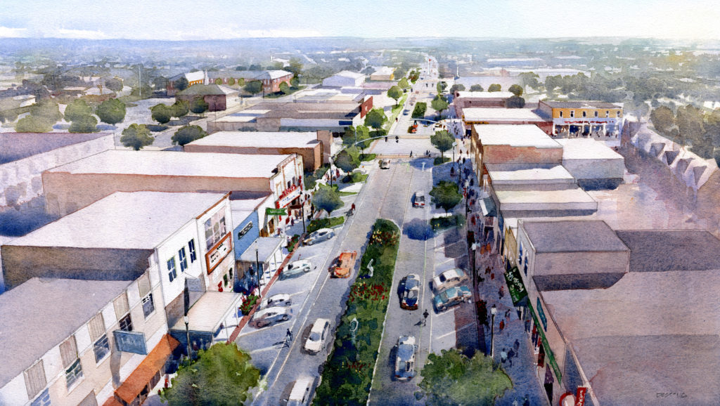
Birdseye Rendering of Downtown Pryor Creek
Pryor Creek Comprehensive Plan, 2017
In 2015, the City of Pryor, in collaboration with Pryor citizens and stakeholders, initiated a year-long process to create its first Comprehensive Plan since 1974—a Plan that creates a new strategic vision and direction for Pryor that capitalizes on the community’s existing assets, including its neighborhoods, excellent schools, the nearby MidAmerica Industrial Park, community services, and local parks and recreational amenities. This Comprehensive Plan aims to guide the Pryor community as it works to enhance its economic and civic vitality, while addressing the challenges of aging infrastructure and limited financial resources.
Libertyville Comprehensive Plan, 2018 (ongoing)|
The Lakota Group is currently engaged in a collaborative planning process with residents and stakeholders to update the Village of Libertyville’s Comprehensive Plan. The final Plan will outline important policies and strategies related to land use and development, downtown, infrastructure and capital improvements, housing and neighborhoods, open spaces and natural resources, transportation, historic preservation, quality of life, and community sustainability and resiliency. You can learn more about this project on the project website.